Skip to content
Menu
p600.org
  • home
  • map
  • trips
  • about
p600.org

Pico da Coroa

hike | 2024-04-07

Another P144 peak, Pico da Coroa, catches my eye on the map. The southern route from Maroços seems like the easiest and most obvious way to reach the summit. I’m practically celebrating the convenient starting point when I hit a snag – literally. Google Maps’ “easiest route” turns out to be a concrete walking trail, complete with stairs! Undeterred, I consider parking my car and hiking the 3 kilometers with 500 meters of elevation gain. But parking presents a bigger challenge. The narrow road is barely wide enough for one car, with a meager 4-meter turning circle at the end. To top it all off, two eagle-eyed ladies from a nearby house are watching my every move. Faced with a dead end (stairs) and the watchful eyes of the locals, I decide on a strategic retreat. With a sigh, I opt to tackle Pico da Coroa from the west side instead.

Following the map, I drive a few kilometers to Stio do Prado and turn onto an unpaved forest road leading towards Pico da Coroa. The first few meters are already a tell-tale sign – water puddles welcome me like a muddy moat. After a few hundred meters, I meet off-road vehicles coming the other way. They stare curiously at my tiny rental car, clearly not built for this terrain. A few more watery mud patches test my resolve, and finally, I hit a deep mud pit. Speeding through might be an option, but the risk of losing a bumper or worse isn’t worth it, especially with a rental car and potential company disputes. With a sigh, I decide to turn around and find another route.

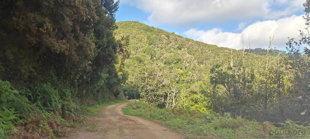
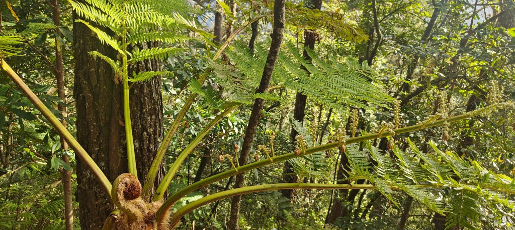
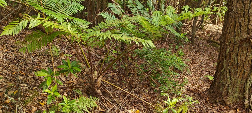
Looks like my rental car isn’t a fan of mud baths (who can blame it?). But hey, gotta give Pico da Coroa a shot! So, with a strategic retreat and a few clicks reversed, I find myself on Caminho da Fajã dos Rojos, or “Path of the Red Fajãs”. Paved road becomes dirt road, but hey, at least my tiny car isn’t part of the scenery anymore! Although, gotta say, these giant ferns lining the path are giving me serious “lost in the jungle” vibes. Maybe I should’ve sprung for the all-terrain upgrade on the rental…

Nearing the summit, the unpaved forest roads held up surprisingly well.
I was amazed to discover so many large ferns here. These plants always conjure up images of tropical jungles in Asia or Africa for me. Looks like it’s time to broaden my horizons!

After a 15-minute drive, I find a parking spot marked on the map as a “picnic area.” Sure enough, two hikers are enjoying a pre-hike meal at a table. With a quick hello, I confirm with them that this is the trailhead for Pico da Coroa. They point me towards the starting point, suggesting I leave my car here and begin the hike.

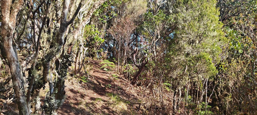
The initial ascent leads to a saddle between two peaks. Turning right, I’m pleasantly surprised to find a good trail! It seems the map wasn’t entirely misleading after all. However, the right branch of the trail is somewhat obscured by branches – perhaps intentionally to avoid confusing long-distance trekkers who might mistakenly take this shorter route.

Penha d’Águia’s unique form is impossible to miss. It’ll be my next hiking objective.
The Atlantic Ocean coast viewed from steep slopes.

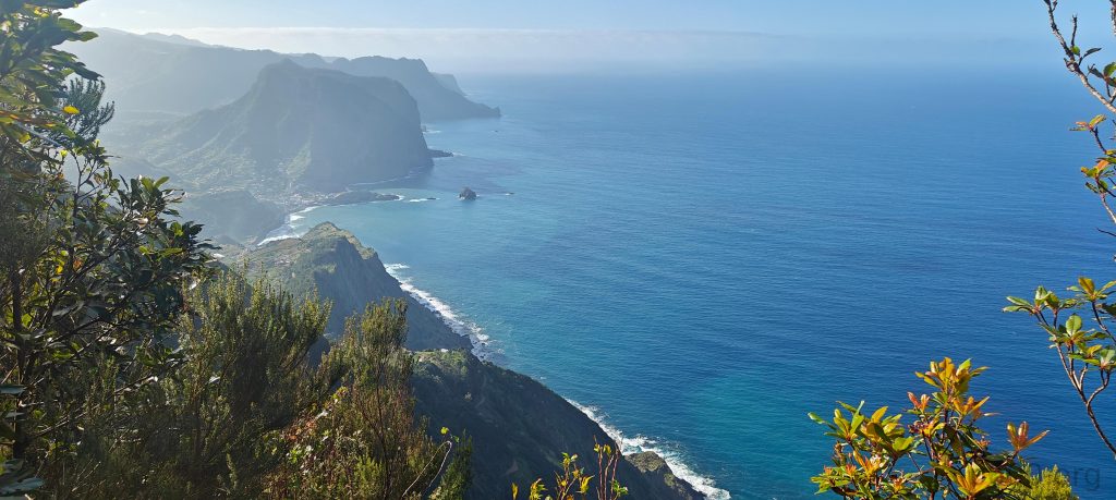
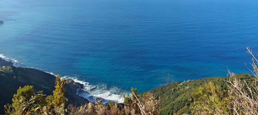
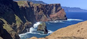
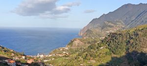
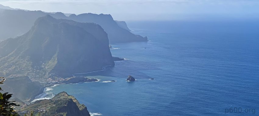
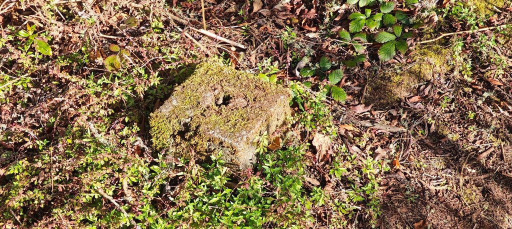
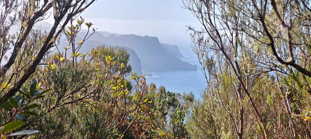
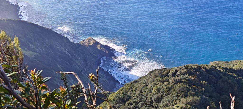
The trail steepens for a bit before becoming more gradual. Along the way, there are one or two spots offering breathtaking views towards the northeast cliffs and the vast Atlantic Ocean. Soon, I reach a point marked as the summit on my peakbagger app. While tempted to stop here, I decide to continue eastward for another 160 meters. The extra effort pays off! My GPS confirms that the eastern bump is a few meters higher, and it even boasts a sturdy concrete marker. These two factors strongly suggest it’s the true summit, but I choose to visit both peaks for good measure.

Look for the small concrete pillar and mushroom to identify the summit.
The trail to the summit is good with a few steeper sections, but overall it’s a relatively easy hike.
Penha da Águia’s coastline unfolds behind the trees, revealing Ponta da Clerigo’s dramatic cliffs jutting into the Atlantic. In the distance, Rocha das Vinhas’ silhouette emerges from the haze.
The view from one of the few viewpoints through the dense vegetation,

On my descent, I encounter the two hikers again, enjoying their post-hike dinner. As we chat, a surprising revelation strikes – we’re neighbors from Žižkov at Prague! This chance encounter reinforces the notion of how small the world can be.

To my surprise, this peak seems unreported by other peakbaggers on my app! This unexpected bonus adds to the satisfaction of reaching the true summit. With five peaks bagged today and a gorgeous day unfolding before me, there’s still plenty of time to explore further. Next on my list is Penha d’Águia, a majestic, standalone rock formation a few kilometers north. Fueled by the day’s success, I hop back in the car and head towards this new objective.


Pico da Coroa734 m altitude
144 m prominence
RangesMid-Atlantic Islands - North Atlantic Islands
Countries/regionsPortugal - Madeira
Distance0.90 km up0.90 km down
Elevation154 m gain154 m loss
Time
0h25 up
0h05 other
0h20 down
0h50 total
Trailhead580 m altitude32.7556110, -16.7988610
RouteThe well-marked trail starts at the picnic area on the bend of the road. I follow it along the ocean cliffs, where I'm surrounded by dense vegetation. As I ascend, I reach a saddle. Here, I turn right and continue towards the two summit bumps, which are 160 meters apart. Once I've enjoyed the views, I simply retrace my steps to descend.
DifficultiesThe initial forest road to the trailhead can be muddy, so a higher clearance vehicle is recommended.
LinksGPX trail
  • Mid-Atlantic Islands 2024
  • « Pico do Castanho
  • Penha d'Águia »

Mountain Ranges

Anatolia
Central Anatolia
Pontic Mountains
Southeast Anatolia
Taurus Mountains
Western Anatolia
Andes
Puna de Atacama
Atlas Mountains
High Atlas
Northwestern Atlas
Central America Ranges
Costa Rica-Panama Ranges
Central Central America
East China
Taiwan
Eastern Europe Ranges
Southeast Baltic Plains
Iberian Peninsula
Cordillera Cantabrica
Castile Ranges
Portugal-Galicia
Pyrenees
Intermountain West
Great Basin Ranges
Korea-Amur Area
Taebaek Sanmae
Malay Archipelago
Java
Nusa Tengarra
Sulawesi
Sumatra
Mid-Atlantic Islands
North Atlantic Islands
Mongolia Ranges
Altai
Gobi Desert Ranges
Hangay Mountains
Northwest Europe
Great Britain
North France-West Rhine Area
Pacific Ranges
Cascade Range
Northwest U.S. Coast Ranges
Sierra Nevada
Central and Southern California Ranges
Philippines
Central Philippines
Luzon
Mindanao
Southeast Asia
Malay Peninsula
Southeast South America
Pampas
Sierras de Cordoba
Southern Africa
Malawi Highlands
West Africa Mountains
Bight of Benin
Cameroon Mountains
Guinea Highlands

Countries / regions

Algeria
Ain Guezzam
Ain Salah
Aïn Témouchent
El Bayadh
Ghardaïa
Oran
Ouargla
Saïda
Sidi Bel Abbès
Tamanrasset
Argentina
Catamarca
Ciudad Autónoma de Buenos Aires
Córdoba
Jujuy
Salta
Tucumán
Belgium
Brussels Capital Region
Flemish Region
Cameroon
Southwest
China
Taiwan
Costa Rica
Alajuela
Cartago
Guanacaste
Heredia
Limón
San José
Czechia
Prague
Denmark
Greenland
France
Hauts-de-France
Occitania
Germany
Berlin
Niedersachsen
Indonesia
Bali
Jambi
Jawa Tengah
Jawa Timur
Nusa Tenggara Barat
Sulawesi Tengah
Sulawesi Utara
Sumatera Barat
Lithuania
Vilnius County
Mongolia
Bayankhongor
Govi-Altai
Khovd
Omnogovi
Ovorkhangai
Ulan Bator
Zavkhan
Morocco
Béni Mellal-Khénifra
Drâa-Tafilalet
Fez-Meknes
Marrakesh-Safi
Souss-Massa
Tangier-Tetouan-Al Hoceima
Mozambique
Zambezia
Netherlands
Gelderland
Noord-Holland
Zeeland
Nicaragua
Chinandega
Managua
Masaya
Rivas
Philippines
Bicol Region (V)
Cagayan Valley (II)
Calabarzon (IV-A)
Central Luzon (III)
Cordillera Administrative Region
Davao Region
Metro Manila
Soccsksargen (XII)
Western Visayas (VI)
Poland
Greater Poland Voivodeship
Masovian Voivodeship
Portugal
Castelo Branco
Leiria
Lisbon
Madeira
Santarém
Qatar
Ad-Dawhah
São Tomé and Príncipe
São Tomé Province
Sierra Leone
Northern Province
Western Area
Singapore
South Korea
Gyeongsangnam-do
Seoul
Spain
Aragón
Asturias
Castilla-La Mancha
Castilla y León
Catalonia
Islas Canarias
Switzerland
Zürich
Turkey
Antalya
Bitlis
Erzincan
Hakkâri
Igdir
Isparta
Kahraman Maras
Muğla
United Kingdom
England
Scotland
United States
California
Delaware
Florida
Maryland
Nevada
New Jersey
New York
Pennsylvania
South Carolina
Utah

TRIPS

2024
Southern Africa 2024
Mid-Atlantic Islands 2024
North America 2024
Anatolia 2024
Korea-Amur Area 2024
East China 2024
2023
Mongolia Ranges 2023
Philippines 2023
West Africa III 2023
West Africa II 2023
Iberian Peninsula 2023
West Africa 2023
Central America 2023
2022
Andes 2022
Northwest Europe 2022
Malay Archipelago III 2022
Malay Archipelago II 2022
Anatolia Mountains 2022
Iberian Peninsula 2022
Atlas Mountains 2022
North France-West Rhine Area 2022

archaeology (3) climb (157) food (2) hike (155) p30 (17) p50 (4) p100 (24) p300 (12) p600 (17) p1000 (11) p1500 (76) ribu (10) sight (46) summary (16) trig (44) ultra (76)

1 591 km walked, 121 298 m climbed

©2025 p600.org | WordPress Theme by Superbthemes.com