As the fourth peak in an eight-hill day, and coming straight from Lotarův vrch, Javorský vrch felt almost suspiciously efficient. After a wooded summit and a longer sequence earlier in the day, this was a very short climb with a very open top, the kind of hill that looks modest on the map and then quietly turns out to be far better placed than it has any right to be. The whole outing took barely half an hour, but it still managed to include a small summit puzzle, broad views, and one thoroughly improbable picnic scene.
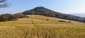
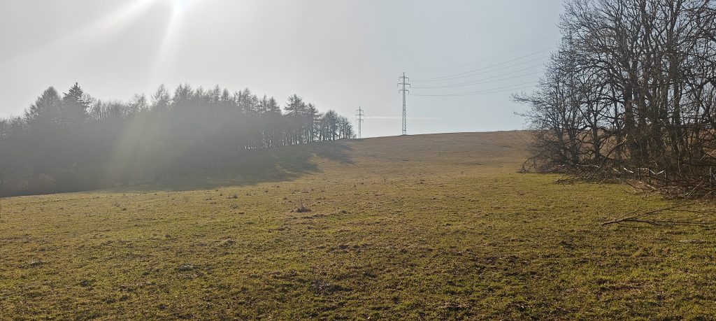
I parked by the road west of Javory and took the direct line across the meadow rather than using a more formal approach. There was not much room to leave a car on the side I used, although it looked as if there was more space from the opposite approach. Once I was there, the direct line made the most sense. The route was simple: grassy slope, open ground, and a steady pull toward the skyline. There were faint traces of tracks here and there, but in dry conditions it was mostly a matter of walking uphill and not overthinking it, which is a nice luxury before the human race inevitably ruins everything with too much infrastructure.
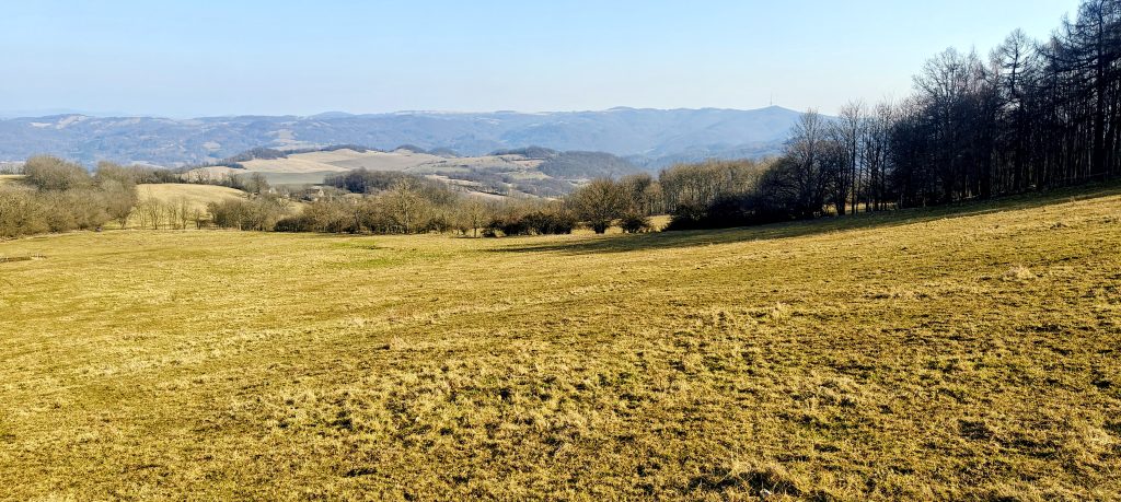
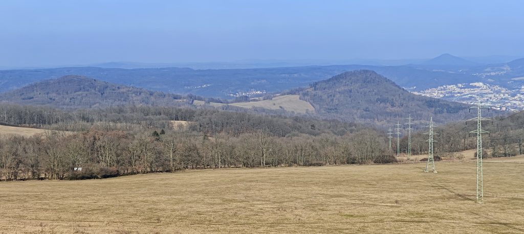
Because the summit is largely open pasture, the views start early and keep widening almost the whole way up. This is not a forest plod with one final lookout at the end. Javorský vrch gives away its main attraction immediately. The climb to the true high point was about 0.78 km and took roughly 19 minutes, with 123 m of ascent recorded over the full outing. For such a short walk, it packed in a surprising amount of landscape: rolling fields, edges of woodland, scattered villages, and those slightly theatrical volcanic shapes that make this corner of Bohemia look as if someone had been sketching hills with a more confident pen than usual.
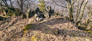
The summit is broad enough that the exact highest point is not obvious at first glance. Just below the flat top I stepped over a low barbed-wire fence, a small reminder that this is working countryside rather than a curated summit. Near the far end of the upper field, the best candidate for the high point was a low pile of stones beside scrubby bushes, with nothing visibly higher nearby.
The real surprise was the company rather than the topography. I met a couple and their dog having a full picnic on the summit, complete with a grill and actual food, which was about the last thing I expected on such an obviously non-tourist bump. On a famous lookout, fine, that sort of thing happens. Here it felt gloriously out of proportion to the mountain, which only made the place more memorable.They seemed as surprised by my arrival as I was by their full summit picnic, and for a moment it felt as if we had all wandered into different versions of the same hill.
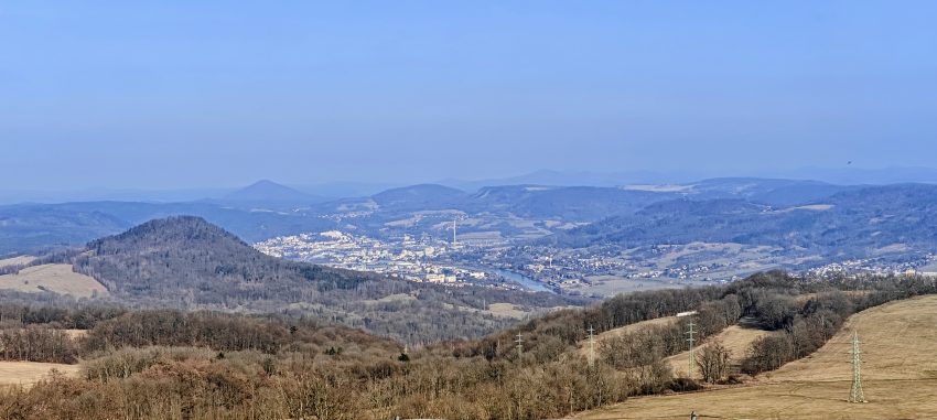
Javorský vrch sits above the village of Javory between Děčín and Ústí nad Labem, and the openness of the summit gives it a wider reach than many higher but more enclosed neighbours. The older German name Lerchenberg, roughly “Lark Mountain”, suits it rather well. This is not a hidden forest top. It is an exposed pasture hill, breezy and outward-looking, with broad views across the Bohemian uplands and toward busier valleys beyond. One of the nice details on a multi-peak day was being able to look back at hills I had already visited, including Lotarův vrch on the left and Chmelník on the right in the wider panorama. That gave the summit a satisfying sense of continuity rather than making it feel like just another short stop between roads.
I went back the same way, descending directly across the meadow in about 13 minutes. Like the ascent, it was simple, fast and completely transparent. There were no route-finding problems, no awkward ground, and no real reason to make the outing longer unless you wanted to connect it with one of the marked approaches from Javory, Jílové or farther afield. As a stand-alone hike it is tiny. As peak four of eight, it was ideal: quick to reach, different in character from the wooded tops around it, and memorable mainly because it managed to be both understated and faintly absurd at the same time. Not every hill needs drama. Sometimes a short grassy climb, a broad summit, good views and an unexpected barbecue are enough.
Approx. timing: start 14:23 | high point 14:42 | finish 14:55
Trailhead / parking: roadside pull-off west of Javory, 50.731233, 14.123984
Summit / true high point: broad grassy high point at approx. 50.731711, 14.114585
Highest recorded GPS point: 619.7 m at 50.731711, 14.114585
Terrain: open meadow, grassy slope, faint field tracks, broad summit pasture
Route: roadside west of Javory -> direct meadow ascent -> broad summit pasture of Javorský vrch -> return the same way
Sections: parking to high point about 19 min; descent about 13 min
Difficulty: very short and non-technical; mildly steep grass on the direct line; low barbed-wire fence at the edge of the summit pasture
Useful to know: parking is limited on the side I used; the summit is broad and only lightly defined by a low stone pile and scrubby patch; power lines run close to the summit but do not pass directly over the high point.