Skip to content
Menu
p600.org
  • home
  • map
  • trips
  • about
p600.org

Velký Bítov: a compact P100 above Struhadlo

hike | 2026-03-14

Velký Bítov was the second summit in my eight-peak day, and it was a good reminder that a peakbagging objective does not need big altitude to be worth the stop. At 713 m, this is not a giant hill by Czech standards, but its 117 m of prominence give it just enough independence to matter as a tidy little collecting peak. It is also the kind of summit where identity matters more than scenery. The obvious top-like place is not quite the real one, and that alone made the hill more interesting than the numbers first suggest.

The route began in Struhadlo village center beside the small monument that marked the practical parking area.

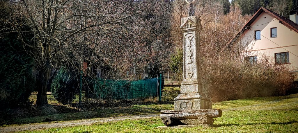
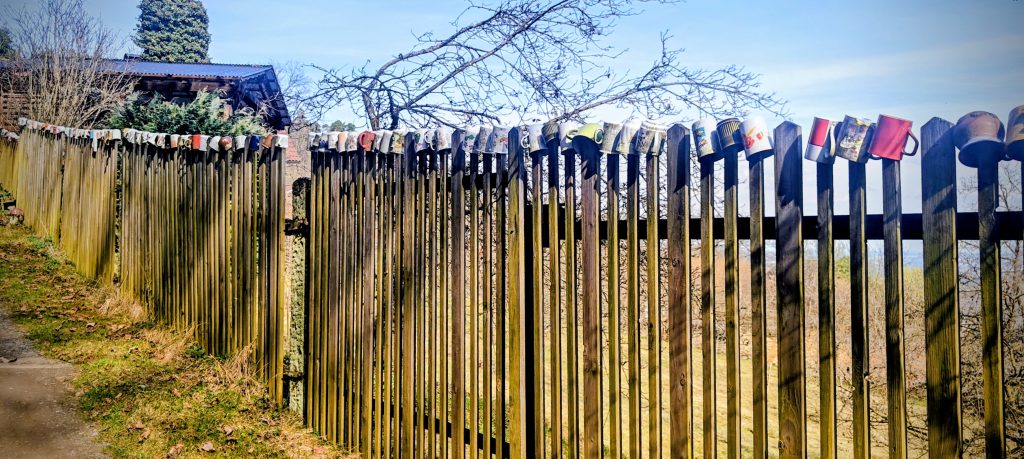
I parked in the center of Struhadlo at roughly 49.389889, 13.178863, beside the bins and the village monument, then walked straight through the settlement to start the climb. The village section was short and ordinary, except for the usual chorus of dogs announcing my arrival from behind fences. One house had a line of old mugs perched along the fence, a small and slightly absurd detail that gave the start more character than most trailheads manage. Once past the last houses, the route settled into exactly the kind of terrain this hill promised: a winding forest road, steady but never serious climbing, and enough logging and fenced regrowth to keep the ascent from feeling like an untouched woodland walk. It was a compact outing from the start. I was not here for a long mountain day on one summit, just for a clean ascent that fit neatly into a larger sequence.

A fence decorated with old mugs added a memorable bit of village character at the start of the walk through Struhadlo.

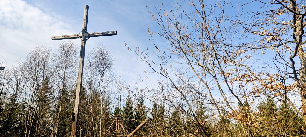
The climb reached a first convincing top at the lower south point, marked in my GPX as 693 m. On the ground, this is the place that tries hardest to pass as the summit. There is a cross, an antenna, a picnic table, and the kind of setup that would send a less stubborn peakbagger back downhill with false confidence. It is the obvious stopping point, and if I had been here only for a village walk with a viewpoint and a symbol, it would have done the job.

The cross at the lower south point is the most obvious summit marker on the route, but it is not the true high point of Velký Bítov.

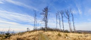
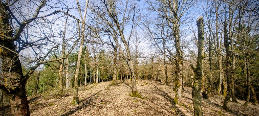
Velký Bítov, however, keeps its actual top a little farther on. From the cross I continued north through the trees toward the user-marked highpoint waypoint at about 49.399784, 13.178474. That short continuation is the whole point of doing the hill properly. The summit area is broad, wooded, and not especially dramatic, with birch, pine, oak, and patches where the forest has been cut back or is growing again. It does not hand you a single unmistakable apex the moment you arrive. Instead, the top is something you confirm by paying attention.

The upper crest of Velký Bítov is broad and forested, so the true high point feels more mapped than theatrical on the ground.

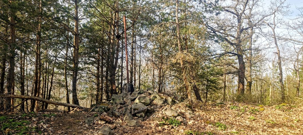
At the true high point, the best marker was not a grand summit feature but a collapsed rock pile with an old rusty triangulation post set into it. That fit the hill perfectly. Velký Bítov is not a summit that sells itself through exposure or huge views. Its appeal is quieter than that. The satisfaction came from reaching the right spot, not just any spot that happened to look summit-like. My track’s highest recorded GPS point was 715.7 m a few metres away at 49.399787, 13.178527, which was close enough to confirm I was where I meant to be. There was also a summit register box nearby on a tree, though I passed by without signing it.

The true summit of Velký Bítov is marked by a ruined stone pile and an old triangulation post rather than by the more obvious cross on the lower point.

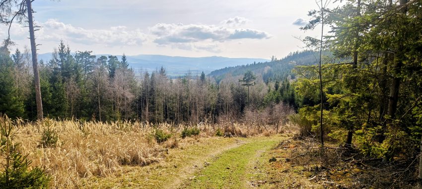
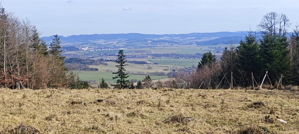
Because the summit itself is wooded, the better visual reward came on the route rather than at the very top. Openings in the forest and cut areas on the descent gave wider looks over the surrounding fields, villages, and low ridges of the region. None of it felt alpine, obviously, because humans remain committed to placing their mountains in inconveniently moderate landscapes. Still, the hill had enough local dominance to make the views feel earned. On a short peak like this, even one or two decent openings are enough to give the ascent a clear sense of place.

A clearing on the descent opened a broad view across fields, villages, and low ridges below Velký Bítov.

I descended by completing the loop on broader forest and logging roads east of the summit ridge. That side of the route was easy to follow and faster underfoot than the upper crest, and it turned the outing into a satisfying little circuit rather than a simple out-and-back. The full loop came to about 3.62 km and took 47 minutes car to car, with about 26 minutes up to the true high point and 21 minutes back down. For such a small objective, it delivered several things peakbaggers actually care about: a defined summit, a small but real prominence value, a practical village start, and just enough summit ambiguity to reward accuracy. More than anything, Velký Bítov worked well as peak 2 of 8. It was quick, clean, and distinct enough to remember on its own, which is more than can be said for plenty of higher hills.

Range: Europe / Eastern Europe Ranges / Bohemian Ranges / Bohmerwald
Administrative regions: Czech Republic, Plzeň Region; Struhadlo, Bezděkov municipality
List / category: Prague P100 (Peakbagger rank #283)
Ascent / descent: approx. 150 m / 151 m from smoothed GPX; raw GPX gain/loss 266 m / 311 m
Approx. timing: 13:15 start / 13:30 lower south point / 13:41 true high point / 14:02 finish
Trailhead / parking: Struhadlo village center by the monument and bins – 49.389889, 13.178863
Summit coordinates: approx. 49.399784, 13.178474 (user-marked highpoint waypoint)
Lower south point: approx. 49.394012, 13.176232 – 693 m
Highest recorded GPS point: 715.7 m at 49.399787, 13.178527
Terrain: village lane, forest road, short summit path, leaf litter, logged clearings, and broad logging road on descent
Sections: Struhadlo to lower south point about 0:15; lower south point to true high point about 0:11; descent loop to the village about 0:21
Difficulty: Easy
Useful to know: The cross and antenna mark the lower south point, not the true summit. Continue past them to the old triangulation remains farther north.


Velký Bítov713 m altitude
117 m prominence
4.00 km isolation
RangesBohemian Ranges
Countries/regionsPlzeň
Distance1.87 km up1.75 km down
Elevation150 m gain151 m loss
Time
0h26 up
0h02 other
0h20 down
0h48 total
RouteFrom the practical parking spot in Struhadlo village center at 49.389889, 13.178863, walk through the village and continue onto the forest road climbing away from the houses. Follow the winding road and paths uphill to the lower south point at about 49.394012, 13.176232, marked by the cross and antenna. Do not stop there if your goal is the actual summit. Continue north along the upper ridge to the true high point of Velký Bítov at about 49.399784, 13.178474, where the best ground marker is the ruined stone pile with the old triangulation post. From there, descend east on broader forest and logging roads and complete the loop south back into Struhadlo.
DifficultiesThe only meaningful difficulty is summit identification. The lower south point with the cross and antenna is more obvious than the real summit, so it is easy to tag the wrong top unless you continue on to the true high point.
LinksGPX trail
  • « Koráb: A Three-Bump Czech P100 Above Kdyně
  • Doubrava, a Survey-Marked Summit on the Czech P100s »

Mountain Ranges

Anatolia
Central Anatolia
Pontic Mountains
Southeast Anatolia
Taurus Mountains
Western Anatolia
Andes
Puna de Atacama
Atlas Mountains
High Atlas
Northwestern Atlas
Central America Ranges
Costa Rica-Panama Ranges
Central Central America
East China
Taiwan
Eastern Europe Ranges
Bohemian Ranges
Southeast Baltic Plains
Iberian Peninsula
Cordillera Cantabrica
Castile Ranges
Portugal-Galicia
Pyrenees
Intermountain West
Great Basin Ranges
Korea-Amur Area
Taebaek Sanmae
Malay Archipelago
Java
Nusa Tengarra
Sulawesi
Sumatra
Mid-Atlantic Islands
North Atlantic Islands
Mongolia Ranges
Altai
Gobi Desert Ranges
Hangay Mountains
Northwest Europe
Great Britain
North France-West Rhine Area
Pacific Ranges
Cascade Range
Northwest U.S. Coast Ranges
Sierra Nevada
Central and Southern California Ranges
Philippines
Central Philippines
Luzon
Mindanao
Southeast Asia
Malay Peninsula
Southeast South America
Pampas
Sierras de Cordoba
Southern Africa
Malawi Highlands
West Africa Mountains
Bight of Benin
Cameroon Mountains
Guinea Highlands

Countries / regions

Algeria
Ain Guezzam
Ain Salah
Aïn Témouchent
El Bayadh
Ghardaïa
Oran
Ouargla
Saïda
Sidi Bel Abbès
Tamanrasset
Argentina
Catamarca
Ciudad Autónoma de Buenos Aires
Córdoba
Jujuy
Salta
Tucumán
Belgium
Brussels Capital Region
Flemish Region
Cameroon
Southwest
China
Taiwan
Costa Rica
Alajuela
Cartago
Guanacaste
Heredia
Limón
San José
Czechia
Plzeň
Prague
Ústi nad Labem
Denmark
Greenland
France
Hauts-de-France
Occitania
Germany
Berlin
Niedersachsen
Indonesia
Bali
Jambi
Jawa Tengah
Jawa Timur
Nusa Tenggara Barat
Sulawesi Tengah
Sulawesi Utara
Sumatera Barat
Lithuania
Vilnius County
Mongolia
Bayankhongor
Govi-Altai
Khovd
Omnogovi
Ovorkhangai
Ulan Bator
Zavkhan
Morocco
Béni Mellal-Khénifra
Drâa-Tafilalet
Fez-Meknes
Marrakesh-Safi
Souss-Massa
Tangier-Tetouan-Al Hoceima
Mozambique
Zambezia
Netherlands
Gelderland
Noord-Holland
Zeeland
Nicaragua
Chinandega
Managua
Masaya
Rivas
Philippines
Bicol Region (V)
Cagayan Valley (II)
Calabarzon (IV-A)
Central Luzon (III)
Cordillera Administrative Region
Davao Region
Metro Manila
Soccsksargen (XII)
Western Visayas (VI)
Poland
Greater Poland Voivodeship
Masovian Voivodeship
Portugal
Castelo Branco
Leiria
Lisbon
Madeira
Santarém
Qatar
Ad-Dawhah
São Tomé and Príncipe
São Tomé Province
Sierra Leone
Northern Province
Western Area
Singapore
South Korea
Gyeongsangnam-do
Seoul
Spain
Aragón
Asturias
Castilla-La Mancha
Castilla y León
Catalonia
Islas Canarias
Switzerland
Zürich
Turkey
Antalya
Bitlis
Erzincan
Hakkâri
Igdir
Isparta
Kahraman Maras
Muğla
United Kingdom
England
Scotland
United States
California
Delaware
Florida
Maryland
Nevada
New Jersey
New York
Pennsylvania
South Carolina
Utah

TRIPS

2026
Pilzen 2026
Ústí nad Labem 2026
2024
Mid-Atlantic Islands 2024
North America 2024
Anatolia 2024
Southern Africa 2024
Korea-Amur Area 2024
East China 2024
2023
Mongolia Ranges 2023
Philippines 2023
West Africa III 2023
West Africa II 2023
Iberian Peninsula 2023
West Africa 2023
Central America 2023
2022
Andes 2022
Northwest Europe 2022
Malay Archipelago III 2022
Malay Archipelago II 2022
Anatolia Mountains 2022
Iberian Peninsula 2022
Atlas Mountains 2022
North France-West Rhine Area 2022

archaeology (3) climb (157) food (2) hike (167) p30 (17) p50 (4) p100 (35) p300 (12) p600 (17) p1000 (12) p1500 (76) ribu (10) sight (46) summary (17) trig (44) ultra (76)

1 622 km walked, 122 648 m climbed

©2026 p600.org | WordPress Theme by Superbthemes.com