Radešín came sixth on an eight-peak day, after Vysoký kámen and before the beautifully unromantic Peak 346, so by this point I was in efficient mode rather than lyrical mode. That suited this hill perfectly. Radešín is a short, practical little climb north of Ústí nad Labem, more of a precise errand than a full outing, but it turned out to have just enough character to stay in the memory. The afternoon helped. It was dry, mostly sunny, and unusually mild for early March, with spring light over the fields and low hills, which made even a very short walk feel better than it had any right to.
I parked exactly at the GPX start at 50.693927, 14.068202 and followed the obvious access road straight uphill. The route is almost aggressively direct. The road runs in a dead-straight line toward the summit area and, according to the surface, seems to have been asphalted at some point in the past. There is a no-traffic sign at the bottom, but on foot it is as simple as these things get. From the start to the true high point it was only about 700 metres with roughly 70 metres of ascent, so this was never going to be a long struggle. The terrain was easy throughout: a firm old road on the way up, then a short step into leaf-covered forest near the top.
What I did not expect was the number of people. For such a minor hill, the place felt oddly busy, with walkers drifting along the power-line corridor and around the summit woods. This was not the first power-line summit of the day with random human traffic on it, so perhaps walking beneath infrastructure is a more established national pastime than I had realised. In any case, the climb itself was quick and uncomplicated. Within about ten minutes I was at the top area, where the real question was no longer how to get there, but what exactly counted as the summit.
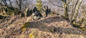
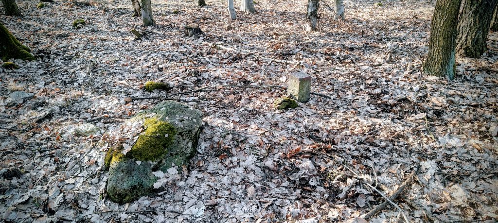
That is the main point worth knowing about Radešín. The summit area is awkward. The power line cuts across the top, and there is a small earth hump near the clearing that could easily fool you into thinking you are done. I do not treat that mound as the natural summit. It looks disturbed, most likely shaped during the construction of the line. The true top, in my view, is a few metres away in the forest, where I found a small concrete trig point and a marker in the trees. That spot matched the summit logic much better than the pushed-up ground by the corridor. There are no grand summit views from the exact high point, just beech woods, leaf litter, and the usual mild satisfaction of locating the correct spot instead of the convenient fake one.
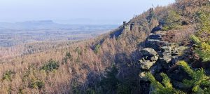
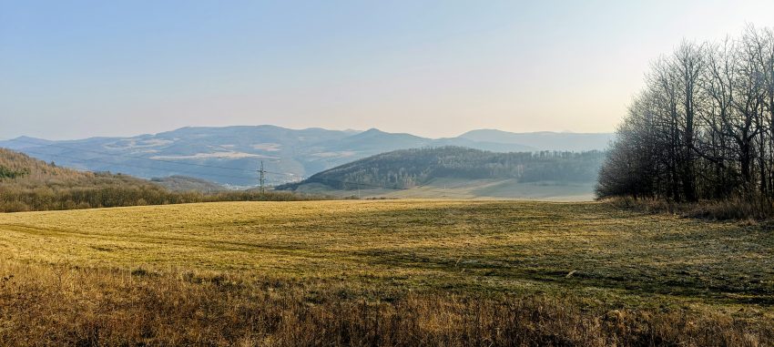
The more open atmosphere comes just below and beside the summit zone, where the forest edge and power-line corridor open the landscape. That was the part of Radešín I liked most. Late-afternoon light was lying across the fields, with rolling wooded hills beyond and the wider landscape above Ústí nad Labem spreading out in soft layers. From the maps, the hill sits in the rough zone between Chuderov, Chuderovec, and Radešín, above the northern side of the city, and that setting comes through well on foot: this is not a remote mountain, but a small high point tucked into the worked countryside, with farmland, access roads, pylons, and bits of forest all pressed close together. It is a very northern Bohemia sort of scene, practical and slightly untidy, but not without charm.
I went back the same way, which was the sensible choice and required no creativity. The whole outing took only about 23 minutes, with the summit reached at roughly 15:58 and the finish a little after 16:10. As a stand-alone hike, Radešín would be too short to justify a major detour unless you are specifically collecting local peaks or prominence hills. As part of a longer day, though, it worked very well. It was easy to access, quick to finish, and just ambiguous enough at the top to avoid becoming a completely forgettable tick.
In the end, that is probably the right measure of the hill. Radešín is not beautiful in any classic summit sense. The top is wooded, the power line is intrusive, and the best part is arguably the approach and the edge rather than the summit itself. But it does have a proper little summit puzzle, a confirmed trig point, a short efficient route, and a surprisingly decent sense of place for such a small climb. I left mildly amused, which is often a better outcome than forced admiration.
Summit / true high point: small concrete trig point in the forest near 50.697234, 14.059517
Approx. timing: 15:47 start / 15:58 summit area / shortly after 16:00 descent / 16:10 finish
Trailhead / parking: exact GPX start at 50.693927, 14.068202
Highest recorded GPS point: raw GPS varied in the summit area; I treat the forest trig point as the true top
Terrain: old straight forest access road, partly former asphalt, short leaf-covered forest section near the top
Sections: trailhead to summit area about 10 min; summit search and short wander a few minutes; return about 10 min
Difficulty: very easy physically; only the summit identification is mildly awkward
Useful to know: the little hump under the power line is likely artificial; the true summit is the trig point in the woods